Why simple GPS tracking is better than no tracking at all
The real value of GPS tracking lies in the complete visibility into your commercial operation. Even a basic, live tracking capability can bring immediate improvements to fleet management and driver safety.
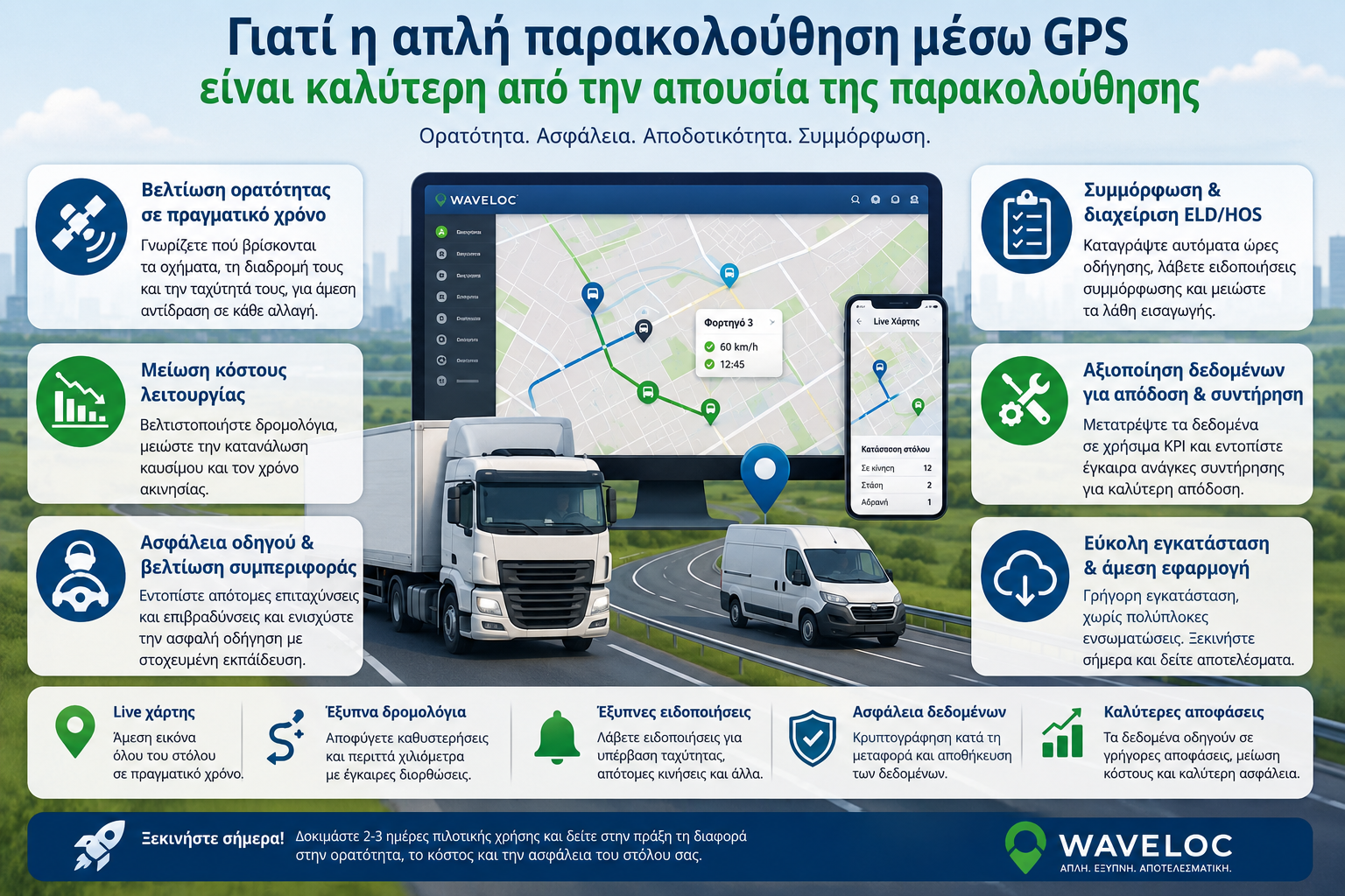
Here are the key benefits you can immediately leverage with a simple GPS tracking platform:
Improving fleet visibility in real time
Real-time location tracking provides an accurate picture of each vehicle’s location, route and speed, providing true fleet visibility. With this data, you can respond quickly to traffic conditions or incidents and adjust routes to reduce delays.
Practical steps:
• Set alerts for sudden acceleration or sudden deceleration to highlight extreme driver behavior. • Analyze 7, 14-day historical data to identify recurring congestion hotspots or routes that need improvement. • Work with customer teams to adjust routes following incidents or changes in demand.
Properly leveraging visibility data helps drive faster decision-making, as managers have an immediate view of fleet status and can adjust resources in real time. Important alerts include unusual routes or areas with poor GPS coverage, where false alerts may appear. With the right setup, alternative routes can be proactively activated before a problem occurs.
Reduced operating costs
Even basic monitoring contributes to reducing fuel consumption and downtime.
- Use the real-time system to identify efficient routes.
- Adjust unnecessary movement scenarios to avoid repeated turns.
- Match itineraries to actual fleet requests and work plans.
- Record performance for specific routes and apply correction in 14 days.
Driver safety and behavior improvement
With the ability to record route and speed parameters, you can highlight specific driver behaviors such as sudden accelerations or decelerations.
- Consider an example where the driver accelerates from 0 to 60 km/h in 4.5 seconds and document the time intervals.
- Analyze when sudden decelerations bring the speed to 0 km/h in 2 seconds to identify extreme changes.
- Use the findings in driver training micro-sessions to ensure smoother accelerations on routes.
Tip: Set system alerts to trigger when the speed difference exceeds a custom threshold.
- Store data geographically on low-range maps for on-the-go applications with Waveloc.
- Protect drivers' privacy and comply with applicable data regulations.
ELD/HOS compliance and management
GPS solutions are often connected to job management systems that automatically record driving times in real time.
1) Examples include automatically exporting data to a log file and alerting when maximum driving time is exceeded. 2) Applications such as Waveloc platforms offer built-in regulatory compliance features, reducing input errors. Practical steps: 1) Enable GPS data synchronization with the company’s ERP. 2) Set up available resources for automatic time reporting. 3) Periodically check logs for unusual events such as repeated signal interruptions.
Important precautions: 1) Ensure data is kept encrypted during transport and storage.
2) Avoid relying on a single GPS provider as network errors can affect accuracy. 3) Keep backups for at least 12 months.
Leveraging data for performance and maintenance
Recording traffic, route and fuel consumption data allows the identification of specific cost and efficiency points.
- Record daily route data in a central repository and extract KPIs from the combined data.
- Calculate critical metrics such as travel time per zone, distance per delivery, and delay percentage on each route.
- Set maintenance priorities based on fuel consumption trends and sensor response, and adjust your maintenance schedule accordingly.
Usability and immediate application
A simple GPS platform can be installed quickly without complex integrations. Check compatibility with existing equipment and test on 2-3 vehicles for a smooth start. Provides clear visualization, live maps and simple action steps.
Practical applications for businesses
Start with a pilot route of 1-2 trips and monitor when sensors alert you to speeding or slow stops. Record the distance from the estimated arrival time and adjust the routes daily.
• Utilize live maps for quick orientation on rural routes. • Increase real-time visibility for quick decisions during loading and delivery. • Avoid unnecessary wasted kilometers with timely route corrections.
If you’re looking for real results with less risk, basic GPS tracking comes as a practical start. Want to see how it works in practice? Try a 2-3 day pilot with fuel cost and arrival time tracking. Visibility improvements lead to faster decisions, cost savings and better safety for your drivers, especially on winding routes.
Import
In the world of transportation, GPS tracking offers clear visibility and reliability in daily operations. For example, a small distribution company can track the location of vehicles in real time and improve routing with major benefits in efficiency and delivery accuracy.
This document explains how simple GPS tracking enhances visibility, resource management and overall operating costs without the burden of a full data system. Practical guidelines are provided for recording vehicle location, speed and status, with an emphasis on traffic conditions and weather data.
Waveloc's range of GPS solutions is designed to be easy to use, flexible and reliable. Capabilities include fleet tracking for 0.50 vehicles, location tracking for goods in tanks or containers, and near real-time visibility without unnecessary technological complexities.
1. Importance of simple GPS tracking in transportation scenes
What does "simple monitoring" mean?«
Simple tracking means installing a basic system that records vehicle locations, speed, and status without additional features or excessive complexity.
It offers instant insight into real-world locations, route history, and crisis alerts, without complicated dashboards.
How daily fleet management is changing
The administrator quickly identifies extreme driver behaviors, measures distances between delivery points and is informed of delays without wasting time on detailed configurations.
Route managers inform staff with clear location data, facilitating task allocation and avoiding route overlaps.
Main benefits in terms of operational performance
Simple monitoring reduces the reliance on complex management software and provides real-time visibility for small and medium-sized businesses. With the right organization, it can help reduce operating costs, better utilize resources, and make faster decisions.
Integration with Waveloc platform themes
Basic GPS tracking complements the overall fleet card picture, providing instant information on vehicle location, speed and condition. Combined with total fleet management tools, it facilitates quick actions to save costs and improve reliability.
Addressing common questions
What is the main advantage? It provides a clear, immediate view of location and status, without the need for complicated settings. What is the correct way to use it? You start by installing a basic GPS system that records vehicle locations, speed and status, and later expand according to the needs of the fleet.
Important references for improving efficiency
Integration with Waveloc's GPS platform can provide near real-time tracking, historical data and alerts, facilitating fleet management without incurring costs with unnecessary features.
Basic practical advice
1) Start with a simple, reliable geo-location system. 2) Keep data on a minimum time horizon for quick decisions. 3) Monitor performance in real time and evaluate data over the long term for KPIs like reduced fuel consumption and improved visibility.
Dynamic setting with real data
For example, a small transportation company managed to reduce shipment tracking time by 18% per month through simple monitoring and reduce fleet overtime by 12% with immediate notification of delays.
Data that can influence the purchase decision
Simple GPS tracking can lead to improved fleet visibility, reduced maintenance costs, and easier task execution, especially for small and medium-sized businesses looking for quick returns without a large investment.
Expert Insight
""Real-time fleet monitoring improves visibility, reduces maintenance and fuel costs, and enables quick, informed decisions that increase performance" , Industry Analyst
2. Economic benefits of maintaining monitoring instead of not monitoring
Reduction in fuel consumption costs
Monitoring allows for alerts to be triggered for excessive consumption and driving habits that increase fuel consumption. By displaying near real-time speed and distance, drivers can improve driving habits without additional equipment costs.
For example, a fleet manager can detect sudden accelerations in urban areas and suggest improvements such as speed adjustments or changes to the routing routine, leading to a reduction in fuel consumption in the long term.
Reducing noise incidents and thefts
Continuous location tracking helps respond immediately to suspicious movements or deviations from pre-defined routes. This proactive monitoring reduces incidents and speeds up vehicle recovery.
In practice, geofence or off-route alerts allow those responsible to react immediately and limit loss.
Increase efficiency and productivity
Recording route history helps identify bottlenecks and optimize route planning. With regular improvements, overall driving time is reduced and resources are used more efficiently.
By replicating data from month to month, coordination teams reschedule routines to avoid peak hours, reducing task completion times and improving delivery accuracy.
• Reduced operating costs through fuel optimization • Reduced losses due to theft and delays • Better coordination of work and planning
3. Improve operational alertness with real-time
Traffic monitoring in near real time
By gaining near real-time visibility, managers can see the location, speed, and trajectory of each vehicle as it moves, making it easier to identify risks early and adapt to active incidents before they impact the business.
Customization teams can suggest alternative routes or inform customers of schedule changes without delay, improving delivery reliability.
Live reporting enhances decision-making in dynamic environments and reduces the risk of incidents.
Easier management of routes and schedules
Location data and history make it easy to monitor and improve route performance with real-time metrics. Managers can quickly adjust resources, reducing wait times and improving ETA accuracy.
Flexibility allows schedules to be adjusted to weekly or daily cycles, improving fleet utilization and customer satisfaction.
Practical improvements with the help of Waveloc
1) Implement pollution management and route prioritization rules with automatic notifications for peak traffic. 2) Use historical data for route improvements and fuel cost reductions.
4. Utilizing GPS data for maintenance and safety
Vehicle status monitoring
GPS data is combined with maintenance measurements to present the current condition of vehicles. Monitor fuel readings, system temperatures and sensor errors without additional equipment.
Preventive maintenance is based on historical data trends. When a vehicle periodically exhibits elevated temperature trends, you schedule a check on mechanical parts before problems arise.
• Maintenance based on actual use • Damage assessment and failure prediction • Reduction of downtime risks at critical operating moments
Preventing dangerous driving and exceeding limits
GPS data supports driver behavior monitoring tools, such as speeding warnings, deviation from predefined routes, and detection of sudden acceleration or sudden braking.
With timely information about exceeding limits or dangerous movements, those responsible can implement educational interventions or route adjustments to reduce risks in real time.
5. Examples of use in various fleet sizes
Small fleets and small businesses
### Small fleets benefit from GPS tracking systems that are easy to install and inexpensive to maintain. Simple tracking covers the basic needs of recording vehicle location, speed and condition, helping to reduce losses and ensure the proper use of resources.
Basic usage examples:
• Easily add one or two vehicles to an existing fleet without long-term commitments. • Real-time location tracking and historical route recording for usage tracking.
Practical application details:
• Install the basic GPS chip in each vehicle and set it to send data every 5 minutes. • Set geo-zones to enforce speed limits in specific areas. • Store data on a cloud platform like Waveloc for faster historical retrieval.
Medium and large fleets
At larger scales, management becomes more strategic with predictive maintenance models, efficient route planning, and increased visibility for multiple managers simultaneously.
Main application points:
• Group vehicles by service type or geographic area for faster feedback. • Integration with data systems for real-time task organization and resource utilization.
Practical tips for large fleets:
• Leverage predictive maintenance models based on time series of logs and usage data. • Create dynamic route maps that adjust routes based on traffic and special orders. • Set up access roles for flexible task allocation.
6. Technology compatibility and ease of implementation
Easy installation and connections
Choose GPS systems that offer instant installation without complicated tools. Opt for models with plug and play connections or easy installation on the road or in vehicles, trailers and engineering components.
If you’re leveraging existing infrastructure, check compatibility with your protocols and interoperability with technologies like cellular, Wi-Fi, and Bluetooth. Proper integration reduces deployment times and maintenance footprints.
Flexible GPS products for different needs
Solutions should cover small to large fleets. Opt for systems that offer both portable and fixed devices.
Consider customization options by vehicle category, from two-wheelers to commercial trucks, and the ability to expand into new assets in the future. Solutions should achieve improvements in agility and cost management.
• Practical example: Trucks and tankers with plug-and-play units on bumper connections reduce installation time to 30, 45 minutes per vehicle, enabling timely load tracking. • Installation initiative: Leverage central service hubs for mass installations across a large fleet, saving labor and time. • Compatibility: Verify that devices require only a standard data line and do not need additional bridges or converters for existing networks.
###
Expert Insight
""By elevating fleet surveillance with intelligent data intelligence, location and environment solutions turn every tow into action: real-time visibility, cargo protection and utilization optimization across all phases of the supply chain." , Industry Analyst
Frequently Asked Questions
Below are basic clarifications regarding simple GPS tracking in transportation activity.
• What is simple GPS tracking? A basic location and speed tracking platform, without complicated options or connected services. For example, a small transport company can see the real-time location of three vehicles from a smartphone. • Do I need special installation? Not necessarily. Many basic systems are plug and play or require minimal installation on vehicles, trailers or equipment. On an electric van, place the receiver in a spot with good reception, without obstructing cables. • How does it improve my company’s visibility? It provides near-real-time location visibility, making it easier to plan routes and reduce delivery times. On a daily basis, use the data to reach more efficient delivery points. • Does it replicate location in real time? Yes, the update arrives in near real time with slight delays depending on the provider and network communication. If the signal is lost, a cache is activated and sent as soon as the connection is restored. • How far does it cover? It covers vehicles, goods and equipment within a geographical boundary defined by the provider. For example, a geographical zone within a city or a region using RSSI-based geographical boundaries.
Conclusion
Simple GPS tracking offers instant fleet visibility without the burdens of complex systems, facilitating timely response to emergencies and improving workflow.
For small fleets, it starts easily and quickly, with lower initial costs, while for medium and large fleets it ensures easy scaling without complicated integrations, maintaining efficient management.
Every business is unique. The right choice leverages GPS data to deter risky behavior, improve real-time resource management, and increase fleet process reliability.
Capture fleet status instantly, improve route reliability and maintain control over daily operational rhythms. Use practical options based on real-time location and speed data, such as automatic slow-motion or accident alerts, including weekly performance reports.

